




When the daily rhythm of the tropics disappears, trouble is near. Learn to read the warning signs of tropical waves and the MJO says Simon Rowell
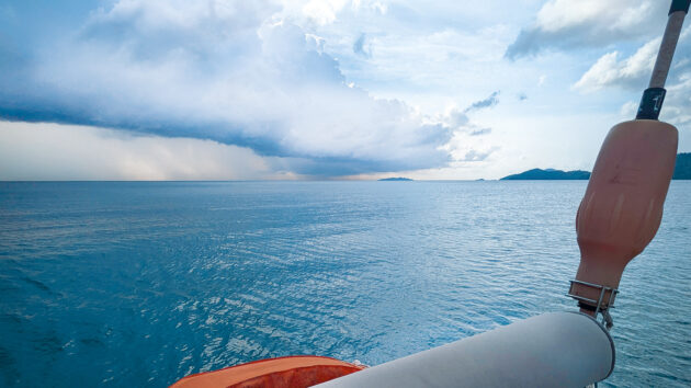
Sailing in the tropics, as you get to within about 30° of the equator the barometer will start to exhibit a twice daily rise and fall, on top of the changes due to the low and high pressure systems.
These changes (small at first but can be up to +/- 1.5-2hPa) are masked by the general weather in the higher latitudes, but the more settled pressure regime of the tropics allows them to be seen. The times of local maximum pressure are usually 1000 and 2200 local time, and minimums are at 1600 and 0400 local time – the relevant pilot book will give the amount of the correction. It’s very important to record the actual pressure in your logbook, and note the correction as a remark – don’t just write down the corrected value.
The timing of this is the clue to its cause: it happens two hours ahead of local noon. The sun’s radiation is short wave, and as such not absorbed much at all by the troposphere. However, the thermosphere, the very outer layer of the atmosphere, is warmed up by the sun and so expands.
The expanding air cannot go to the east, as that has already been warmed, and so goes west. This means that there is physically a little more air above the ground just ahead of the sun, which means there is a slightly higher pressure (no more than 4hPa in 1,000hPa) ahead of the sun, at 1000 local time. This sets up a wave which has two peaks and two troughs around the globe (much like tide), hence another maximum 12 hours later with minimums in between.
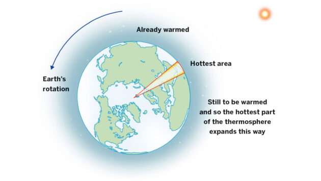
Diurnal variation, looking at the earth from above the North Pole
This shows up well on a barometer, as demonstrated by the Clipper Race yacht CV20 going through the North Atlantic Intertropical Convergence Zone (ITCZ) last September. It can be somewhat disconcerting the first time you notice it, but it’s also rather useful as a measure of how stable the weather is.
If diurnal variation becomes very small or even disappears completely it means there is an atmospheric disturbance nearby – this could be a tropical wave (as described below), a large cluster of squalls with much deep cumulus activity, or – if you’re in the wrong part of the world at the wrong time of year – a tropical revolving storm.
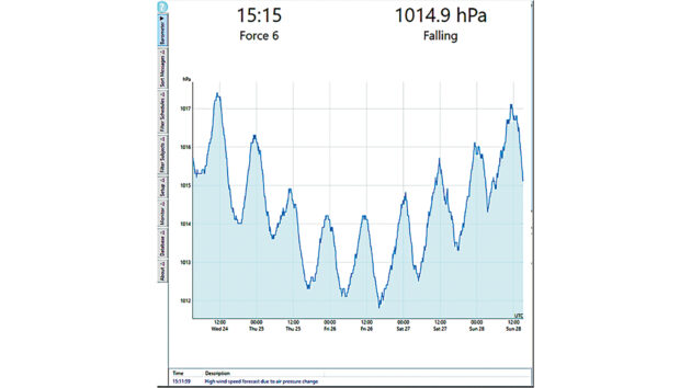
Diurnal variation on SY CV20 – they were two hours behind UTC, so 1200UTC was 1000 ship’s time. The diurnal variation clearly shows, and actually set the barometer’s ‘high wind expected’ alarm off
Tropical Waves
Tropical waves are also known in the North Atlantic as African easterly waves, and are a direct result of the Sahara Desert being consistently significantly hotter than the seas around it.
This causes a large temperature gradient with the sea at the equator being cooler than the Sahara.
This temperature difference gives us a mid-atmosphere jet stream, called the African easterly jet (AEJ), going from above the Sahara to the Caribbean and sometimes even into the East Pacific. This can carry significant quantities of Saharan dust out to sea and over to the Caribbean.
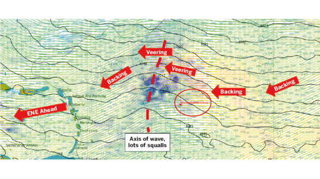
The tropical wave that passed over the rowing boat Monkey Fist Adventure (tiny red triangle) in February 2020. Note the isobar shape (1mbar spacing), the squall activity around the wave’s axis, and the wind backing ahead of it, then veering behind before finally backing to the trades again
The AEJ causes mid-level disturbances every two to three days, very much like eddies on the edge of a fast moving stream of water, and these are tropical waves.
They are effectively troughs moving to the west at about 15-25 knots, with the wind backing then veering as they go over, and more convection therefore more squall activity, increased wind and gusts with more rainfall.
They are normally not dangerous in themselves, and are actually a good opportunity to replenish water tanks, but can be the triggers for hurricanes depending on the time of year.
In September these waves are strongest, and in September approximately 40% of them go on to develop into named storms, ie winds greater than 34 knots. Some of them do continue through the Caribbean and into the tropical East Pacific, and in the summer these can trigger tropical revolving storms there too.
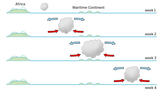
The Madden-Julian Oscillation cycles over the Indian Ocean and maritime continent
The example shown above passed over the rowing boat Monkey Fist Adventure en route to Antigua from the Cape Verdes.
Madden-Julian Oscillation
The Madden-Julian Oscillation (MJO) is an alternating period of either increased or suppressed convection with anything from a 30- to 60-day cycle, which moves around the globe in the tropical regions. Why is this important? It has a significant effect on the weather at sea, particularly in the tropical Indian and West Pacific oceans.
It may well trigger cyclones in those areas and it is the reason why some weeks are just full of squalls, and others full of bright, clear skies. An area of convection will start in the Indian Ocean and move westwards, becoming larger all the time until it is many hundreds of miles across by the time it reaches the maritime continent (Singapore, Indonesia, the Philippines, and all the other island states to Australia).
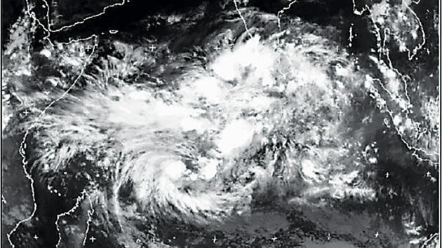
Thermal infrared images on 2 May 2002 showing the large areas of increased and then suppressed convection over the Indian Ocean as the Madden-Julian Oscillation passes to the east, as well as the two cyclones possibly triggered by the MJO
Also, the north-east trades coming down to Singapore would be made stronger if this was approaching, and would be weakened if one was departing to the east. This convection could also potentially act as the trigger for a tropical revolving storm.
The effect is shown by two thermal infra-red images (above) taken a week apart. The first shows the entire southern Indian Ocean under deep convection (the higher the clouds the colder they are, appearing white on thermal infra-red images), the second a week later shows the suppressed convection behind the MJO wave, as well as two cyclones possibly triggered by its passing. This is one of the parameters used in tropical revolving storm forecasting.
 If you enjoyed this….

Yachting World is the world’s leading magazine for bluewater cruisers and offshore sailors. Every month we have inspirational adventures and practical features to help you realise your sailing dreams.Build your knowledge with a subscription delivered to your door. See our latest offers and save at least 30% off the cover price.
Note: We may earn a commission when you buy through links on our site, at no extra cost to you. This doesn’t affect our editorial independence.