
All but the hardiest and most devoted of minimum sailors will have some form of chartplotter aboard and Orca is certainly a game changer in the field
This article in association with Orca:
Identifying the most efficient route for a passage under sail and estimating ETAs are far from trivial tasks and can therefore absorb huge amounts of time, both in preparation and while at sea. Navigators frequently need to juggle tidal gates with weather forecasts and their boat’s performance in different weather conditions, which can vary widely
Professional race navigators use high end complex routing systems, but this is an expensive solution that requires a very steep learning curve. By contrast Orca has created an intuitive alternative with a streamlined user interface that can be used without expert knowledge.
This small start-up company, created by a trio of marine electronics experts, has a software-first approach that’s fundamentally different to traditional marine electronics companies. This has enabled it to create a neat integrated solution covering everything including display of sensor (instrument) data, chart plotting and excellent weather routing for sailing yachts.
Impressively, it delivers this functionality on iOS and Android phones and tablets. Orca also runs on any M-series Mac desktop or laptop computer. As is customary in the software industry, updates releasing new features and chart updates are regularly rolled out.
In addition it’s also a cost effective option. Orca’s chart coverage is automatically available for all users while online in many countries, including the UK. Cartography currently extends to almost all European and North American waters, plus Australia and New Zealand, in addition to a broad swathe of the Caribbean.
No subscription is required to use these charts while online in all but a handful of jurisdictions, making it an ideal tool for passage planning at home. Adding a €49 annual Orca Plus subscription enables charts to be downloaded for use at sea, while the Orca Smart Navigation subscription (€149/year) enables all functionality including automatic rerouting, AIS with images and three years of Logbook history.
This also unlocks a hybrid chart option in which chart data is overlaid onto high resolution satellite images. This is an immensely useful aid, highlighting obstructions, seagrass beds, changes of depth and other important features.
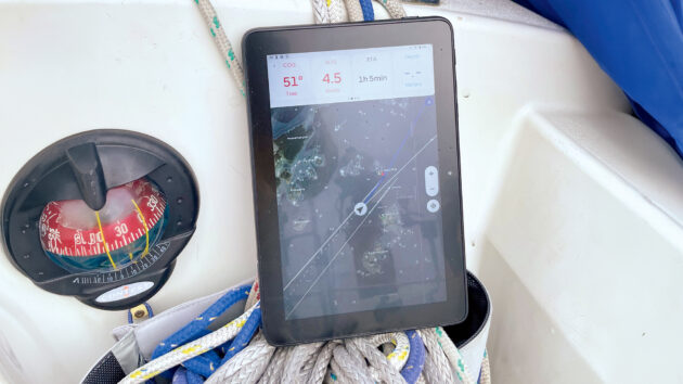
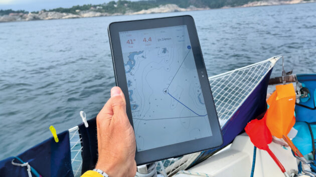
A further key attraction lies in the streamlined interface, with a minimum of unnecessary on-screen clutter. Charts are therefore clear at all zoom levels, with instant redraw as you zoom, scroll, or pan. They are created using data from official hydrographic offices, private entities, and the firm’s own data collections.
Nevertheless, it’s arguably the weather routing functions that most clearly set Orca apart from more traditional marine electronic systems. Routes are tailored for your boat and Orca learns from you and other users. In addition, the Sail Routing option can use polar data for each yacht, along with tide data and weather forecasts, to calculate thousands of potential routes, before selecting the fastest track.
Of course, it often becomes impossible to precisely follow a planned route once at sea. The boat may sail faster or slower than predicted, unexpected tacks or gybes may be needed to avoid other traffic and wind shifts may occur earlier or later than forecast.
These scenarios and others are addressed with an Automatic Rerouting feature that continuously monitors progress and changes in weather forecasts. Routes are recalculated when tacks occur earlier than planned, or when significant wind shifts are detected, for example, with users prompted to check and accept the updated courses.
As well as massively speeding up the passage planning process, this slick end-to-end routing functionality has the potential to shave a tangible amount of time off, for example, a cross-Channel trip.
Recent improvements include significantly better results in areas with navigational constraints. At the same time, the algorithm has also been adjusted to give a larger margin of safety around obstacles.
A new weather experience function provides a detailed hour-by-hour representation of predicted weather changes along your route. This shows where you will be at any given time, along with the forecast for that location and time, making it very easy to understand the weather you will experience at every part of the route.
The Orca Explore function is a powerful passage planning and exploration toolkit. Users can search for waypoints and anchorages by name or geographical coordinates, while integrated weather overlays, including wind vectors, tidal streams, and atmospheric data, can be laid on top of planned routes. This creates a comprehensive pictorial view of the key elements of each passage plan, giving navigators and their crews a clear and easily digested picture of what to expect at each stage of their passage.
Orca also produces two hardware products designed to unlock the full potential of its software. The Orca Core performs two functions: it’s a Smart Navigation Hub with a built-in GPS, compass, heel sensor, and sailing processor. It also offers an easy route to NMEA2000 integration, with Wi-Fi/Bluetooth networking, and live feeds of everything on the boat’s data bus, including GPS, heading, depth, wind and AIS data. Radar overlay is also possible, as is autopilot control.
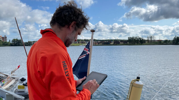
The ultra-bright Orca Display 2 was developed to provide a powerful yet waterproof tablet that’s easy to read even in bright sun and won’t overheat, thereby addressing the key problems associated with navigation using a consumer tablet or iPad for navigation.