



Hurricanes, typhoons, and cyclones are all tropical revolving storms and need to be fully understood by any aspiring ocean sailor. Simon Rowell reports
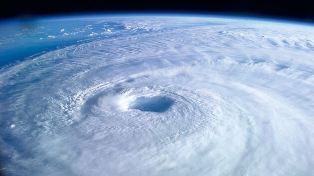
Tropical revolving storms (TRS) are called different things depending on where you are in the world: hurricanes in the North Atlantic and East Pacific, cyclones in the East Pacific and Southern and Northern Indian Oceans, or typhoons over the West Pacific.
For North Atlantic storms, the Saffir-Simpson Scale is used to rate a hurricane’s maximum sustained wind speed:
- Tropical depression (TD): Up to 34 knots
- Tropical storm (TS): 35 to 63 knots
- Category 1 hurricane: 64 to 82 knots – Beaufort F12 or above.
- Category 2: 83 to 95 knots
- Category 3: 96 to 113 knots
- Category 4: 114 to 135 knots
- Category 5: Greater than 135 knots
Once they are tropical storms (ie F8 or above) they become named storms. If a system has a name it doesn’t necessarily mean it’s going to become a hurricane, but it’s certainly worth keeping an eye on it!

Northern hemisphere illustration of a typical TRS
Once surface rotation starts there are six conditions for tropical revolving storm (TRS) development:
- Moisture: Dry mid-tropospheric layers snuff a TRS out.
- Rotation: More than 5° away from the equator brings enough Coriolis effect to create the spin.
- Little vertical shear: The difference in wind speed from surface to the top of the troposphere. If this is large then vertical air movement is inhibited.
- Upper level divergence: Air moves out from the centre at the top of the troposphere, allowing air to rise up from the surface.
- A trigger: Something like a tropical wave with increased convection.
- Sea surface temperatures above 26°c to more than 60m: The source of heat and moisture for the TRS, even with a large sea state.
The first five happen through the year, but the sea surface temperature condition implies consistent warming and so hurricane seasons occur when the sea is warmest.
This is why the North Atlantic hurricane season is approximately June to November, with early season hurricanes starting in the warmer Western Atlantic or Caribbean waters, and approximately November through April in the South Pacific.
Recommended actions to avoid a northern hemisphere TRS
Signs of approaching TRS
TRSs are usually well forecast, so if you’ve any communication off the boat then you’ll have some warning. However, Murphy is a sailor, so if your systems go down there are observations you can make at sea.
- Wind: They vary in size, but a ‘typical’ one has tropical storm (35 knots plus) winds about 150 miles from the centre. A large one has these winds at 300 miles out. In the North Atlantic the wind is usually east/north-east, backing as it approaches. In the southern hemisphere the trades are usually east/south-east, veering as it approaches.
- Swell: They generate a long swell from the direction of their centres (at least where they were at the time). The usual wind-driven swell period in the North Atlantic is 7 to 10 seconds, increasing 12 to 15 seconds from the east if there’s a TRS there.
- Clouds: They throw out much moisture and wind at the upper levels, visible as cirrus between 300 and 600 miles out. As the TRS approaches this thickens and lowers, until heavy walls of cumulonimbus clouds with rain bands and squalls appear 200 to 400 miles from the eye.
- Barometric pressure: The eye of the storm can have remarkably low pressures (eg 888hPa for Hurricane Gilbert in September 1988), and if the barometer consistently drops below what has been the norm be wary. A TRS is not a steady system, and the vast amounts of air coming into, going up and coming out of one cause minor fluctuations in surface pressure known as a pumping action. This makes the usual diurnal variation disappear.
Satellite radar and visual images of Hurricane Isabel (a Category 5 Atlantic storm which struck the US in 2003, photo below) show the scale of a TRS, with the inner cloud walls showing up well on radar, indicating much rainfall there. Also there aren’t any individual weather fronts, as it’s all the same air mass.
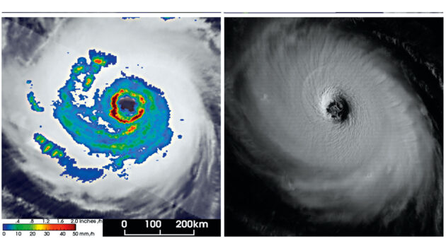
Hurricane Isabel seen on radar (left) and from a satellite view
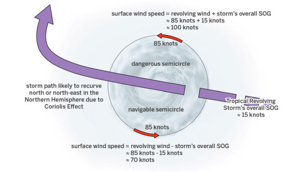
The whole TRS usually (there are exceptions) moves at 15 to 25 knots, leading to the designation of the ‘dangerous semicircle’ on the polewards side of the track and the ‘navigable semicircle’ on the equatorwards side.
Are you being followed?
The wind you see on the surface is the vector sum of the wind speed around the centre and the forward speed of the TRS itself. The example of Hurricane Isabel gives sustained winds of 100 knots in the dangerous semi-circle, and 70 knots in the navigable semi-circle.
A further problem is that the TRS is more likely to recurve to the north and north-east in the northern hemisphere, south and south-east in the southern hemisphere, and so if you are polewards of its track it could end up following you.
To see which semicircle you are in the path of, use Buys-Ballot’s law: if you stand with your back to the wind in the northern hemisphere the centre of the low will be to your left, and if in the southern hemisphere to your right.
Because of surface friction the wind will angle in towards the low by about 15°, so once you’re standing with your back to the wind, move the relevant arm (left in the north, right in the south) forward 15° and take that bearing – that is where the TRS centre is.
In the northern hemisphere if this bearing veers towards south then the eye is moving south of you and you’re heading for the dangerous semi-circle. If it backs towards the north then it’s the navigable semi-circle. Conversely, in the southern hemisphere if it backs towards the north the dangerous semi-circle has you in its sights, and if it veers towards the south the navigable side is approaching.

Images shared on Facebook show the devastation in Carriacou, Grenada after Hurricane Beryl.
Avoidance Actions
If you’re in the dangerous semi-circle then either:
- Try to cross ahead of the eye into the navigable semicircle, or
- Go as close to the wind as you can on starboard (port in the southern hemisphere) and follow it round to move away from the eye’s track.
Turning round and heading out on starboard is usually the only option, with the risk that the TRS recurves and follows you.
If you’re in the navigable semi-circle, then still stay on starboard (port in the southern hemisphere) but on a broad reach taking you away from the path of the eye. It’ll still be dangerous, and the storm may decide to follow you, but it’s better than being on the other side.
 If you enjoyed this….

Yachting World is the world’s leading magazine for bluewater cruisers and offshore sailors. Every month we have inspirational adventures and practical features to help you realise your sailing dreams.Build your knowledge with a subscription delivered to your door. See our latest offers and save at least 30% off the cover price.
Note: We may earn a commission when you buy through links on our site, at no extra cost to you. This doesn’t affect our editorial independence.